

Live flight tracking websites are very helpful. They allow you to see the actual location of flights around the world. You can create a simple scanner using a Raspberry Pi 3 that will allow you to track nearby planes!
“Automatic Dependent Surveillance – Broadcast” or ADS-B is a signal broadcast publicly by airplanes that sends out flight location information and allows it to be tracked. There are several ways that an airplane enthusiast can receive these signals and plot a plane’s location. One of the easiest ways to do this is with a Raspberry Pi 3 and a RTL-SDR USB dongle.
Tracking planes with a Pi is pretty simple to do, all you need is an RTL-SDR, a Pi 3 running Raspbian and the ADS-B mapping software. When the software is running, the RTL-SDR receives the airplane’s signals, and then plots their location on a map. It is kind of like looking something up on Google Maps, but also be able to see its location in real time.
I used the following equipment:
- NooElec NESDR SMART USB with its standard telescoping antennae
- 7” Raspberry Pi Touchscreen running Raspbian
- Dump1090 ADS-B mapping software
I used the 7” Raspberry Pi Touchscreen for my project, because I like the all in one capability. But it would work just as well with a Pi 3 in a normal case, using a monitor, keyboard and mouse.
There are several flight tracking software options out there and also several ways to interface them with existing “Live Air Traffic Tracking” websites. For my project, I used the install tutorial on the Flightradar24 Forum:
https://forum.flightradar24.com/threads/10232-How-to-Install-dump1090-mutability_1-15-dev-on-RPi
I simply followed the step-by-step instructions from the link above. Though, I only followed up to Step 11, as I really didn’t want to install the Data Feeders, will only be using it rarely, and only wanted to see local flights. Adding the Data Feeders would allow you to communicate with the Flightradar 24 website database.
Once the software is installed you are all set, just make sure your RTL-SDR dongle is connected and reboot the Pi.
In a web browser, surf to:
[Pi 3 IP address]/dump1090/gmap.html
Now what is really nice is that with the Pi connected to your local network, you can remotely view the data as well as view it directly on the Pi. On a Windows 10 system, I opened the web address above and planes quickly came into view on the map as seen below:

It was interesting too to see planes from different countries flying overhead:
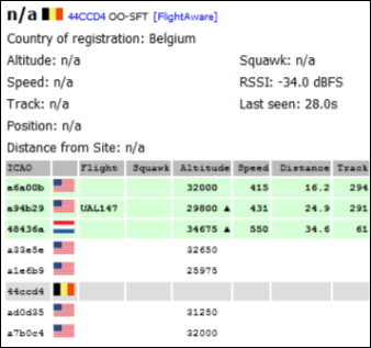
Most of the time the returns will list tail numbers, altitude, speed, along with plotting the position on the map. But as you can see the two images of the Belgium flight that I posted do not contain that information, and only lists the flight number, country of origin and when it was last seen.
For my project, I only wanted to view nearby flights. But if you tie your Pi flight scanner into the live traffic websites with the data feeders, your scanned information will be added to their database and you can also see other planes outside your scanning range.
There are other RTL-SDR’s and antennas out there that are specifically made to receive flight signals, but just using the NESDR SMART I was able to see flights out to about 50 miles. Tracking Airplanes with a $35 Raspberry Pi and a $25 RTL-SDR dongle is a fun and easy project!


Leave a comment